Trolltunga is the most spectacular rock ledge in the world and one of the most iconic places in Norway. You may not be familiar with the name, but you will undoubtedly recognize this place by the photos. Trolltunga is a small rock with a fantastic view that grows from the majestic Skjeggedal mountain. Climbing to Trolltunga in Norway is not easy, so I am going to give you some useful information on how you can make your trip a memorable experience.
Why is Trolltunga So Special?
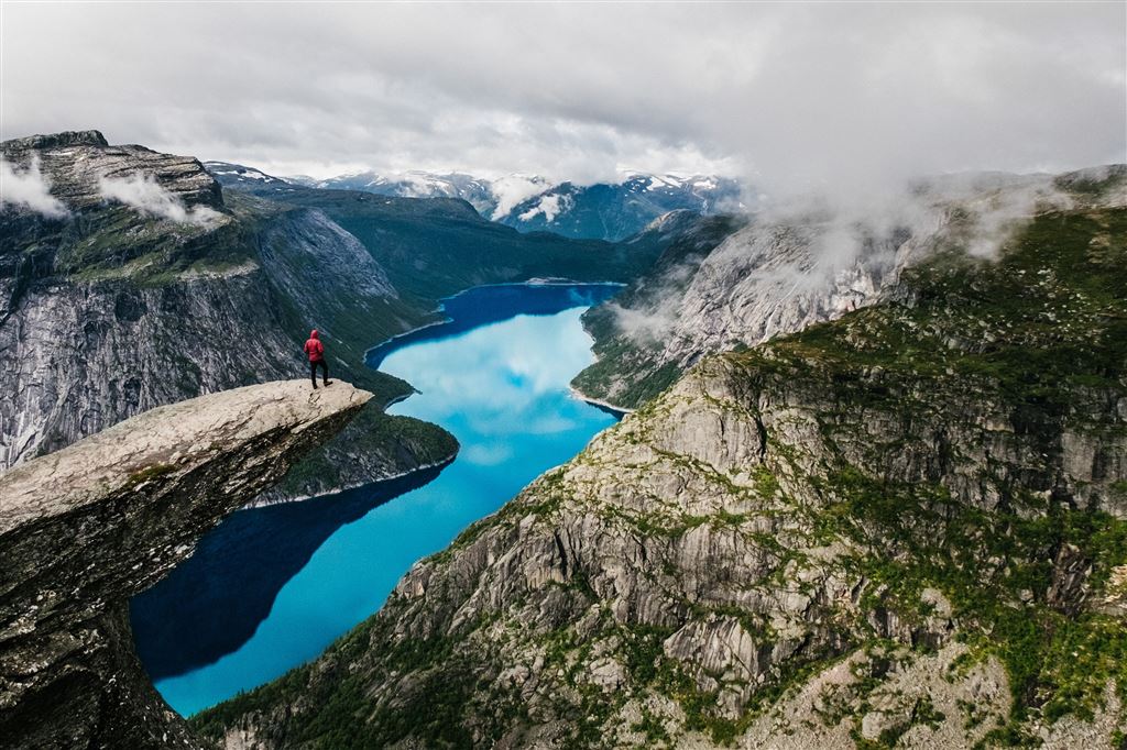
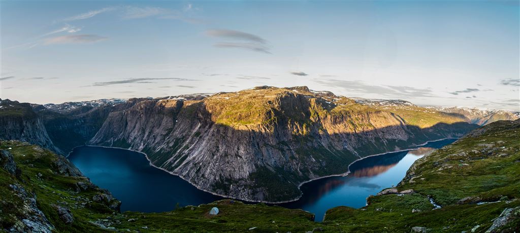
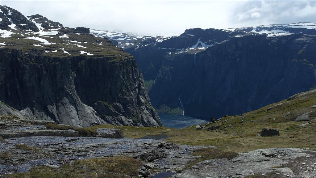
The Rock Tongue, hanging 700 meters above the lake of Ringedalsvatnet, has been one of Norway's most celebrated attractions for several years. It's amazing that few people are daunted by the fact that taking a picture on the top of Trolltunga (Troll's language) requires a 23 kilometers trek across the mountains.
This unique rock formation was created 10,000 years ago as a result of glacial erosion. The glaciers have formed the whole region, and despite the warming of the climate, they still cover the upper parts of the surrounding mountains. The view of Trolltunga is impressive at first glance. A flat and long fragment of rock protrudes above the cliff for several meters and resembles a vast, tapering tongue at the end. The moment Trolltunga's photos started circulating on the web, many years ago, tourists started appearing on its path with a fervor.
A Description of the Route
Have you seen beautiful photos from the Trolltunga and cannot wait for the trip? That is great, but I have to cool down your enthusiasm a bit. Trolltunga trail is demanding and is not suitable for people who are not fit.
You have to realize that there are 1100 meters of elevation change from the point where you start to where you finish your trek. The whole route is about 23 kilometers long, and depending on where you start, the round trip takes 10-12 hours. That is a lot. However, it is hard to meet anyone who would say it was not worth it.
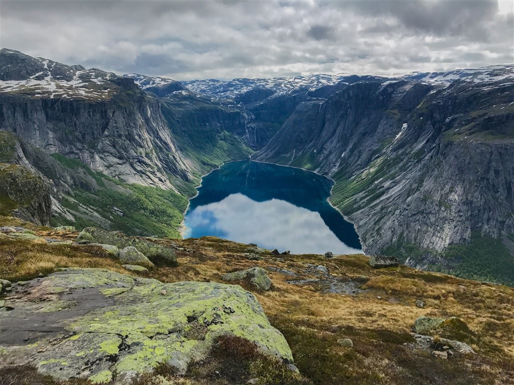
The route starts from the car park in Skjeggedal, and already this stage can deter those who are not ready for challenges. You will go through the first 400 meters climbing the stone steps, and then you will take a rest when you get to the lake. After passing the lake, the second steep begins at the top of the plateau. From there, the generally flat 8 km route leads to the ledge.
The trail is visible throughout the entire stretch, with markings in the form of stone mounds. Depending on the weather, you should expect some mud and wet stones, especially at the steep climbs to the top. Another problem arises after arrival at the top. After the arduous climbing, you have to be aware that you will be waiting for the photo at least about 30-45 minutes in the queue.
As I wrote before, Trolltunga has become very popular, and it is one of the few places in Norway where you have to stand in line to see nature. If you do not feel like it, a few meters further is a smaller, but similar rock shelf, where with a bit of luck you will not meet anyone. After you are done, return the same route to the parking lot.
Mågelibanen Track Trail
Mågelibanen is an abandoned track trail, and if you are comfortable with "hardcore" experiences, this topic will excite you. If you lucky enough to get there before Mågelibanen closes, you can significantly speed up your climbing. Using its old wooden stairs, you can get to the top of the mountain.
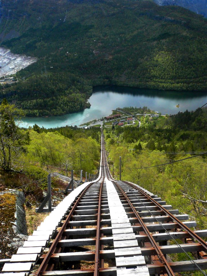
At the beginning of the journey, the levels of the terrain are horizontal, so climbing is not as steep as on traditional path, but after some time the stairs became very vertical and much more strenuous. However, the view from the place where track trail ends is stunning, so if you can manage it, I would highly suggest going.
Further Climbing
Okay, so you climbed to the top of the mountain using the stairs of the abandoned queue. From there you will have just 10 kilometers more to get to Trolltunga.
Let's continue our climb. On the way to the Trolltunga, you will go through many streams and numerous rocks. Along with necessary breaks, you will need another 3 - 5 hours to get to Trolltunga, depending on your condition. Luckily, the return journey is relatively easy and much more comfortable than climbing. However, I think the beautiful views will reward you for this long journey.
How to Get There
The beginning of the trail leads through the small town of Odda. It is located at the end of the Sørfjord, and then climbs the bottom of the Tyssedal valley, ending after 7 km in the car park in Skjeggedal. In the season, parking spaces fill up quickly, so if you are driving a car, it is safer to leave the car in the parking lot in Tyssedal and take the local bus from Odda to Skjeggedal.
If you do not have a car to Odda, you can take bus number 930 from Bergen (www.skyss.no), from Oslo by bus Haukeliekspressen or from the Nor-Way line (www.nor-way.no). In summer, from mid-June to mid-September, there are also tourist buses between Preikestolen and Trolltunga (more on www.gofjords.com).
When to Go to Trolltunga
The primary climbing season in Norway is from June to September, so it is probably the best time to go to Trolltunga. Climbing at another time can be dangerous, so you should not do it without a guide or unless you have experience hiking in similar conditions. Additionally, if you are planning your trip there, start preparing by working on your conditioning.
How Long does the Trek Last?
To go to Trolltunga, you will need a minimum of 10 hours (maybe even 12), because you will have to climb 23 kilometers (with the return route) through the mountains. If you are very fast, you can do this route in 8 hours, but I would not count on it because the trek is tough.
Important Things to Remember
- The route is open from mid-March to mid-October. However, you can only wander without a guide between mid-June and mid-September.
- Because the trail is demanding, you should have the right outfit, comfortable mountain boots, a bottle of water, and a charged telephone.
- You have to begin climbing early in the morning, preferably before 9.00.
- It is worth downloading one of the free maps of Norway with marked routes, e.g., Norgeskart.
- There is no hostel on the route, only a mountain cabin for a few people.
- In several places along the route, you can replenish water from streams.
- Skydiving is not allowed in the Skjeggedal area. It can be only done in the upper part of the trail.
- You should bring waterproof climbing huts, plenty of food and water, sun cream and of course a camera. You can also take a first aid kit just in case.
- Climbing the stairs of an abandoned cable car can be dangerous.
- The car park costs 200 NOK for 12 hours.